Talk:30
Jump to navigation
Jump to search
polygon created
7/27/2023,
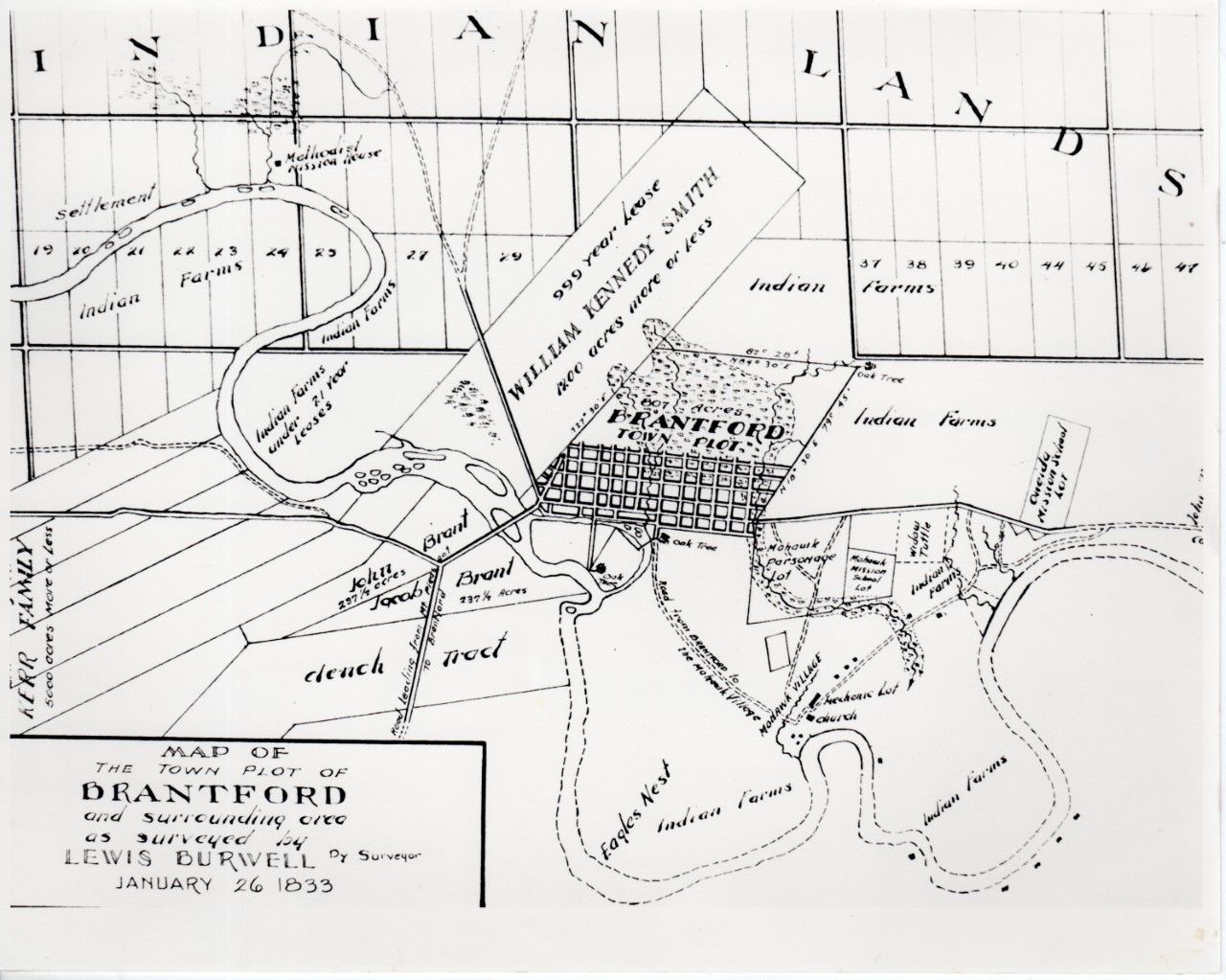
polygon created, but because of landscape change, possible inaccuracies in the burwell map, its hard to know how accurate this polygon is.
notes
lewis burwell map of brantford 1833 jan 26
available in this doc and in bigger formats elsewhere: http://brantmuseums.ca/wp-content/uploads/2017/05/Diary-of-the-Survey-of-the-Indian-Surrender.pdf
helpful links
https://www.sixnations.ca/LandsResources/cslc28.htm https://landconflict.newmedialab.cuny.edu/Brantford/Gage.html
Parsed metes and bounds
| Metes and Bounds Description | Directional Bearing | Distance (Chains, Links, Rods) | Distance (Meters) | Notes |
|---|---|---|---|---|
| Commencing where a stake has been planted on the north side of the road leading from the Grand River bridge through the village of Brantford towards Ancaster, now called Colborne street, and fifty links on a line bearing north five degrees thirty minutes west magnetically from the north-west angle of the Mohawk Parsonage ground | N 5° 30' W | Mohawk Parsonage grounds found in the historic brantford (burwell 1833) map available here:http://brantmuseums.ca/wp-content/uploads/2017/05/Diary-of-the-Survey-of-the-Indian-Surrender.pdf and here: https://smartcdn.gprod.postmedia.digital/nexus/wp-content/uploads/2023/04/map.jpg | ||
| Thence north eighteen degrees thirty minutes east magnetically, seventy-nine chains forty-five links, more or less, to a white oak tree | N 18° 30' E | 79 chains, 45 links | 1592.62 m | Seems to be along Stanley St. |
| Thence south eighty-four degrees thirty minutes west magnetically eighty-two chains twenty-eight links, more or less, to where a stake has been planted on the eastern boundary line of William Kenedy Smith’s land | S 84° 30' W | 82 chains, 28 links | 1653.42 m | |
| Thence south twenty-seven degrees thirty minutes west magnetically along the said boundary line fifty-nine chains twenty-six links, more or less, to a certain stone, and northern extremity of Robert Biggar’s land | S 27° 30' W | 59 chains, 26 links | 1190.44 m | |
| Thence south fifteen degrees west magnetically along the eastern boundary line of the said Robert Biggar’s land twenty-eight chains fifty links, more or less, to where a stake has been planted at high water mark on the north side of the Grand -River, or Ouse | S 15° W | 28 chains, 50 links | 570.29 m | stone is mentioned in other treaties |
| Thence along the northern bank of the said river with the stream to a certain white oak tree standing at high water mark sixty-four links below the outlet of Nathan Gage’s saw-mill race | ||||
| Thence north twenty-five degrees fifteen minutes east magnetically twenty-four chains thirty links, more or less, to where a stake has been planted at high water mark on the south bank of a certain cove | N 25° 15' E | 24 chains, 30 links | 486.44 m | |
| Thence along the south bank of the said cove with the stream fourteen chains eight links, more or less, to a cluster of soft maple trees | 14 chains, 8 links | 283.86 m | ||
| Thence north thirty-four degrees forty minutes east magnetically eight chains, more or less, to a certain white oak tree standing on the summit of the main bank on the north side of the said cove | N 34° 40' E | 8 chains | 160.93 m | this point and the others above correlate to points on the burwell map, there are many changes to the landscape that have occured since the map which makes it a bit difficult to accurately map |
| Then north five degrees thirty minutes west magnetically seven chains fifty-five links, more or less, to within four chains of the south side of the aforesaid road, or Colborne street | N 5° 30' W | 7 chains, 55 links | 156.69 m | |
| Thence north eighty-four degrees thirty minutes east magnetically, and parallel to the said road or street, forty-five chains four links, more or less, to the eastern limit of the said Mohawk Parsonage ground | N 84° 30' E | 45 chains, 4 links | 907.40 m | |
| Thence north five degrees thirty minutes west magnetically five chains, more or less, to the place of beginning | N 5° 30' W | 5 chains | 100.58 m |